We’ve just returned home from a weekend (May 2-4, 2008) with the Hansens at Arches National Park over in Moab, Utah. We’ve been meaning to go over there for years, and we finally made it. We left after school and work on Friday afternoon – the drive is about 333 miles each way – so we didn’t arrive in Moab until about 10:30 at night. We stayed at the Super-8 motel, so it was nothing fancy, but it was a fine place to sleep, especially since the town was booked up with various events.
We got up dark and early on Saturday morning, had the continental breakfast at the motel (juice, donuts, and granola) and headed over to the park. Even though the sky was clear and sunny, the day was relatively cool; with our wet cool spring this year there were wildflowers in bloom all over the place. In the park we made a whirlwind pass through all of the premier sites, starting with the overlook of Park Avenue, a little trail named after the towering skyscrapers in Manhattan. At the other end of the Park Avenue trail we stopped and took a photo of some rock climbers scaling one of those giant red cliffs. Then we drove up the road a bit – of course, I made Robert stop every mile or so to take photos of this amazing place, with its myriad arches, starter arches, fallen arches, impossible rock towers, and “Petrified Dunes” – to the Balanced Rock, which looked a bit like a giant natural Moai (from Easter Island;) we took the walking path all the way around the rock – it’s only 0.3 miles.
Just beyond the Balanced Rock we turned off, drove past the Garden of Eden, and parked at the Windows Section. We took the 1-mile trail over to see the Turret Arch and the North and South Windows; I don’t know the difference between an arch or a window, but they were all very cool to see. From there we took the short drive over to the next stop, and took the 1-mile hike up into the Double Arch, with two giant arches joined at one end (like a “Y”.) There are a couple of caves next to the Double Arch that we hiked up to also – they were cool looking, but not much to see inside. From our perch up in the Double Arch, looking north, we could see what was called the Cove of Arches, with several other smaller arches – there were arches everywhere we looked. In fact, there are 2000 documented arches in the park, and I don’t suppose we saw more than about 1% of them.
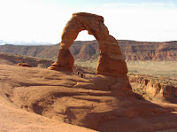
From there we drove over to the Delicate Arch viewpoints (Delicate Arch is the one on our license plates) – the lower viewpoint just 100 yards from the parking lot, and the upper viewpoint about ¼-mile hike up the hill from the parking lot, where you can see the arch beautifully silhouetted across the canyon. We saved the hike over to the Delicate Arch itself for the next day. On our way back out to the main road we passed the Pot Hole Arch – an arch that’s oriented like a basketball hoop.
Then we drove up to the end of the road, to the Devil’s Garden, a 7.5 mile walk that starts off by threading between these huge red sandstone towers. The first stops, not far up the trail, are the Pine Tree Arch (so named because it has a Juniper Pine tree growing in it) and the Tunnel Arch (kind of a double arch, which is thick like a tunnel.) A little further down the trail you see these huge red sandstone elephant heads, like elephants on parade in a petrified circus. Then comes the huge and much photographed Landscape Arch – impossibly thin as it spans over 300 feet from base to base. You can’t get too close to the Landscape Arch since a huge chunk fell out of it a few years ago, so now they have it fenced off, in case the rest of it decides to come raining down. Here we found a nice patch of shade, backed up against a large cliff-face and had our lunch. Then, right on the path a little further along, we came to Wall Arch – it’s like an arch in a large stone wall. Further along the path there are two spur trails; we took the left one first, to Partition Arch, a double arch, from which you can see down on the main trail. The second spur (back to the fork in the road and then to the right) led us to Navajo Arch; this arch is halfway buried in the sand. Then we hiked on top of a little 5-foot-wide backbone of sandstone (with some tourists behind us crawling on their hands and knees) until we came to the Black Arch, so named because it’s silhouetted against a black wall of sandstone behind it. Around the corner (and over hill and dale) from there we found the Double-O Arch, which could just as easily be called the Figure-8 Arch since the two arches were stacked vertically rather than horizontal from each other. There were some crazy guys walking along the top of the top arch – very much against the rules. From there you can either return the way you came, which is the most common choice, or take the scenic route called the “primitive loop” which takes you down below all of the rocks over which you’ve scrambled to get this far. On a little spur trail off of the Primitive Loop, there is the Private Arch, which is the only arch on the return via the primitive loop.
All told we hiked around 10 miles that day, which was plenty for my poor knees – about my limit for one day. I’m glad we went early in the day – not only was it cool, but the crowds all seemed to be behind us. There were lots of people still pulling in to the park as we were leaving. When we’d done all of the hiking and site-seeing that we could for the day, we headed back to Moab and the hotel where we spent about an hour in the hot tub soaking the kinks out of our sore muscles. That evening we went to a casual steak house for Annie’s birthday dinner (although her birthday was really on the 4th.)
On the morning of the 4th, we got up dark and early again, and headed back to the park for a couple more quick sites. First I dropped Robert, Kody, and Leslie off at the Park Avenue Trailhead and picked them up at the bottom of the hill (about one mile later.) Leslie said that the hike was through these huge tall rocks that looked like the skyscrapers of Manhattan (hence the name “Park Avenue.”) While they were hiking I took some photos of Fallen Arch, which is now some big rocks where they surmise had been an arch or two but have since fallen down. Then we hiked over to Delicate Arch and passed two other less-famous arches along the way. It was a three mile round trip hike of mostly up on the way there and then mostly down on the way back – I huffed and puffed all of the way up (it’s a good thing I work out every morning) and then winced at my arthritic knees (still sore from the day before) all of the way down. Since it was early we practically had the place to ourselves – it was great. We took pictures of the arch, in front of the arch, under the arch (see photo above), and even risked the steep slickrock on the backside to take pictures behind the arch. On our way back to the car we took a little detour to see some petroglyphs of Indians on horses, with dogs, chasing Bighorn Sheep – they were cool.
All told I took nearly 200 photos. We passed a whole bunch of tour buses arriving in the park as we were on our way out – perfect timing for us. After checking out of the hotel, the Hansens decided to head straight home, but we decided to have Annie’s birthday brunch at Denny’s right next to the motel before driving home. From there we drove straight home and thankfully, although I got really sleepy, the drive was uneventful. Here at home we found everything in order, so we can count this as another successful vacation trip.